

Burn hundreds of extra calories every week and keep fit just by getting off the tram one or two stops early on your commute and walking the rest of the way. A new Manchester Metrolink Map of Calories will show you how.
Developed in collaboration with GP Dr Wayne Osborne, the map shows how many calories on average you can burn walking between stops on the Manchester tram network.
The NHS recommends at least two and a half hours of cardiovascular exercise such as walking every week or 10,000 steps per day. The map helps makes this manageable, opening up a new possibility of using the city to achieve your fitness goals.
And rather than dissuading people from using public transport, the intention behind the map is to encourage people to swap small sections of their commute for physical activity.
It’s already been successfully applied to the London Underground map so the Manchester Metrolink has just as great potential.
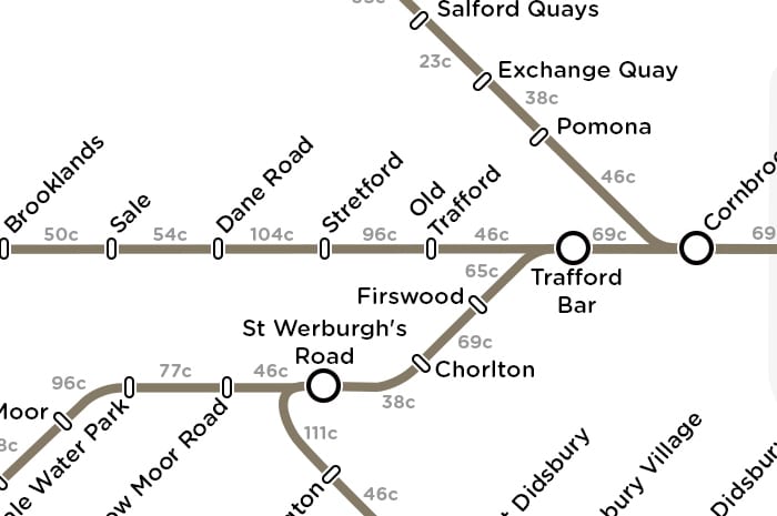
For example, the map shows that by getting off at Victoria rather than St Peter’s Square and walking the rest of the way – a distance of just under a mile and a brisk 15 minute walk – you could burn an extra 285 calories per week. Calculations are based on someone weighing 11 stone – the average UK weight – walking at 3 miles per hour.
Whilst the distance between some tram stops is short – between Victoria and Exchange Square burning just 15 calories (congratulations, you’ve earned yourself an After Eight mint) – if you’re more ambitious, bigger stretches such as Stretford to Dane Road will burn 104 calories, entitling you to a two finger Kit Kat with your lunch.
For the more ambitious, a calorie-busting walk from Crumpsall to Victoria will burn 242 calories. Treat yourself to a Mars bar. You’ve earned it.
The routes between tram stops can open up some fascinating new ways of looking at the city. A walk between Cornbrook and Pomona gives you a chance to look out over Manchester’s post-industrial landscape, whilst Burton Road to West Didsbury is a scenic stroll through leafy suburbia.
The map proves that making small changes to include more exercise into our everyday lives is possible. It’s great for cardiovascular health, maintaining heathy circulation function and reducing the risk of high blood pressure. And if your walk crosses fare zones, you’ll save yourself a few bob, too.
What’s not to love?
See the map here